|
Nottawasaga Valley Conservation Authority 2015 Report on the Environmental Health of the | |||||
|
This report card is a measurement of the health of the Oak Ridges Moraine and adjacent Greenbelt subwatersheds within the Nottawasaga Valley watershed. Human health and well-being are affected by the quality of our natural environment. Monitoring increases our understanding of watershed health and helps target programs and activities to where they are needed most. It is also a tool used to track progress, identify changing conditions and target areas that require protection or enhancement. Two of NVCA's subwatersheds: Innisfil Creek (Bailey Creek and Beeton Creek catchments) and the Upper Nottawasaga River -- include portions of the Oak Ridges Moraine and the Greenbelt (Escarpment and Protected Countryside).
This report card was prepared by the Conservation Authorities Moraine Coalition to provide science-based information to inform the 2015 review of the Greenbelt Plan and the Oak Ridges Moraine Conservation Plan. Funding support generously provided by the Friends of the Greenbelt Foundation.
Where is NVCA within the ORM?
Where is the ORM within NVCA?
|
|
The Overall Grade for the health of the watershed is based on four variables:
*Please Click One of the Variables below for more Information | |||||
Forest Conditions |
Surface Water Quality |
||||
Groundwater Quality |
Coldwater Fish and Stream Temperature |
||||
| Forest Conditions | Grade: |
Trend: None MORE INFO |
|||
Overall Forest Conditions Indicator
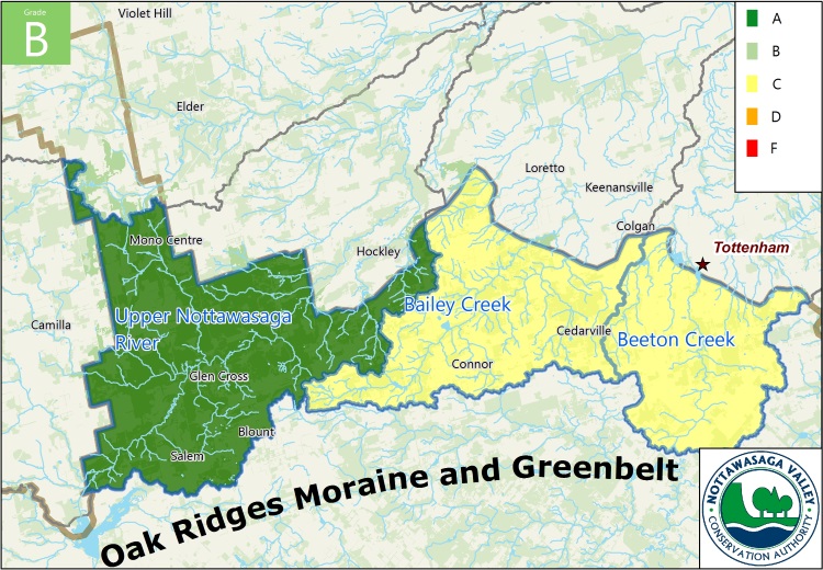
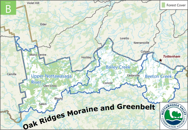
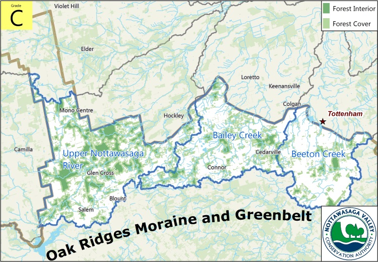
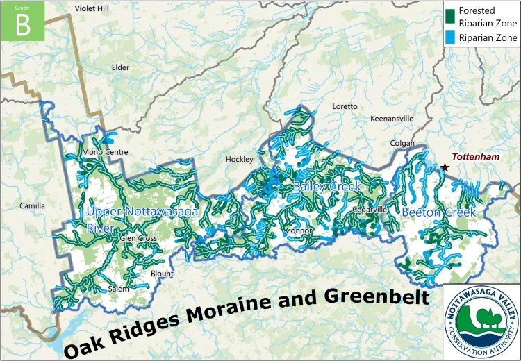
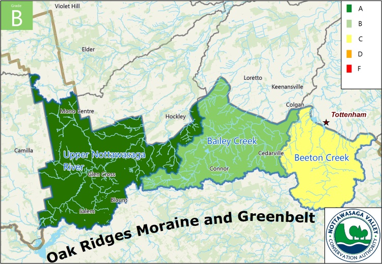
Forests are a major component of a watershed and contribute to the overall health of the watershed ecosystem. Forests along the Niagara Escarpment support rare wildlife such as Louisiana waterthrush and the endangered Jefferson salamander. Coniferous and mixed forests along the Nottawasaga River valley provide important winter habitat for deer. The Forest Conditions Indicator is measured using three variables: overall forest cover, forest interior and forested riparian area. NVCA land cover mapping was used to define the spatial extent of forest cover. Overall, the portion of the Nottawasaga Valley watershed within the Oak Ridges Moraine (ORM) and Greenbelt received a B grade. The three subwatersheds within the ORM/Greenbelt are Upper Nottawasaga River (Grade of A), Bailey Creek (Grade of C) and Beeton Creek (Grade of C). Since Bailey and Beeton Creeks received the lowest grades, it is recommended that tree planting be focused in these areas under NVCA's Healthy Waters and Tree Planting programs. Forest Cover Forest Cover is the percentage of the watershed that is forested. Environment Canada suggests that 30% forest cover is the minimum needed to support healthy wildlife habitat; more coverage is beneficial. Between 2002 - 2008, forest cover in the Upper Nottawasaga River, Bailey and Beeton creek subwatersheds increased, with a net gain of 43.8 ha. While this is a positive trend, the overall grade for the Nottawasaga Valley watershed within the Oak Ridges Moraine (ORM) and Greenbelt is B. The Upper Nottawasaga River subwatershed has 51% (Grade A) forest cover, while Bailey Creek (35% - Grade B) and Beeton Creek (25% - Grade C) have less forest cover. NVCA tree planting efforts should be focused on Beeton Creek with a goal of 'bulking up' and reconnecting forest cover on the subwatershed landscape. Forest Interior Forest interior is the area of forest that lies more than 100m from a forest edge. This represents deep forest habitat which is physically separated from the windy, dry conditions and predators that are associated with the forest edge. Sensitive forest birds, mammals, reptiles and amphibians require deep forest habitat for survival. Environment Canada suggests that 10% forest interior cover is the minimum needed to support a range of species. The overall grade for the Nottawasaga Valley watershed within the Oak Ridges Moraine (ORM) and Greenbelt is B. Significant forest interior habitat (15% - Grade A) is present in the Upper Nottawasaga River subwatershed but is lacking in the Bailey Creek (5.2% - Grade D) and Beeton Creek (3% - Grade D) subwatersheds. Both subwatersheds would benefit from reforestation projects that 'bulk up' smaller forest patches. Riparian Forest Streamside forest cover (riparian forest) filters pollutants and provides important fish and wildlife habitat. Environment Canada suggests that at least 30 m on each side of the stream (over 75% of its length) should be in natural cover to support healthy streams. The overall grade for the Nottawasaga Valley watershed within the Oak Ridges Moraine (ORM) and Greenbelt is B. Excellent riparian forest cover (64.8% - Grade A) is present in the Upper Nottawasaga River. Healthy riparian forest cover (44.8% - Grade B) is associated with the Bailey Creek subwatershed, while riparian cover in the Beeton Creek subwatershed (31.5% - Grade C) is only fair. Streamside planting programs along Beeton Creek and its tributaries, targeted in the non-forested blue areas shown in the map below, would help improve stream health and reconnect forest cover on the landscape. |
|||||
| Back | Overall Forest Conditions Indicator | Forest Cover | Forest Interior | Riparian Forest | |
 | |||||
 | |||||
 | |||||
 | |||||
| Surface Water Quality | Grade: |
Trend: None MORE INFO |
|||
Surface Water Quality Indicator
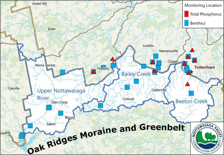
The assessment of surface water quality for the Oak Ridges Moraine (ORM)/Greenbelt Report Card was based on total phosphorus (TP) and benthic macroinvertebrates (see accompanying description). These two indicators are recommended by Conservation Ontario for reporting on surface water quality. Funding from the Friends of the Greenbelt Foundation was essential to support TP sampling and analysis in the NVCA portion of the ORM and Greenbelt study area. Surface water quality is associated with forest conditions in the riparian area (edge of stream) as well as natural cover and other land uses throughout the associated drainage area. The overall grade for the Nottawasaga Valley watershed within the ORM and Greenbelt is B. With healthy forest cover and riparian forest cover, it is no surprise that the Upper Nottawasaga River had good TP and benthic index grades (Grade A and Grade B, respectively). Bailey Creek followed the forest cover trend with intermediate TP and benthic index grades (Grade B and Grade C) while Beeton Creek reflected poorer TP and benthic index grades (Grade B and Grade D). Click here for more information on NVCA's Watershed Monitoring Program. Total Phosphorus & Benthics Invertebrates Total Phosphorus is an indicator of nutrient levels within a stream. Some nutrients are needed to support life; however, excessive nutrients result in algae blooms, potential fish kills and poor water quality. Provincial Water Quality Guidelines suggest that levels greater than 0.03 mg/L result in unhealthy stream conditions. With the exception of the Hockley TP station on the Upper Nottawasaga River where 2008-2013 sampling data was available, all other TP station analyses are based on 2013 sampling data that was generously funded through the Friends of the Greenbelt Foundation. Benthic Macroinvertebrates (BMI) are insects and other aquatic organisms that inhabit the streambed and are excellent indicators of stream health. They are generally abundant, easy to sample, relatively stationary and sensitive to environmental stressors. The Hilsenhoff 1988 Family Biotic Index (FBI) was used to analyze surface water quality based on BMI. Five years of sampling data within the period 2008 to 2013 were used to calculate the grades. Together, TP and BMI provide chemical and biological indicators of water quality and are used to grade the three subwatersheds included in the ORM analysis. |
|||||
| Back | Surface Water Quality Indicator | Total Phosphorus & Benthics Invertebrates | |||
Reforestation of riparian areas, promotion of best management practices on agricultural lands and decommissioning of on-line ponds are three ways by which NVCA is working with the agricultural community and other landowners to improve the health of our surface water in the ORM and Greenbelt. 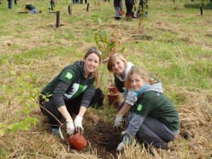
| |||||
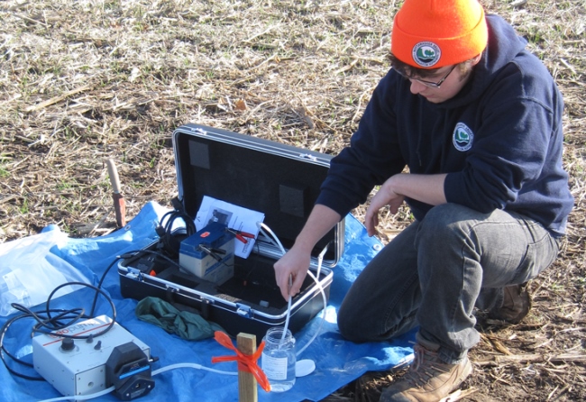
Determining surface water quality involves biologists sampling creeks and wetlands for things like: insects, mollusks, crustaceans and worms. They also test total phosphorus levels which are also used to determine the health of a stream. 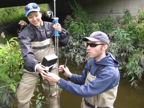
| |||||
| Groundwater Quality | Grade: |
Trend: None MORE INFO |
|||
Groundwater Quality Indicator
Groundwater Quality for the Oak Ridges Moraine (ORM)/Greenbelt Report was based on chloride and combined nitrite/nitrate levels. These two indicators are recommended by Conservation Ontario as they reflect key issues related to groundwater quality across the province. Groundwater is water that is stored underground in bedrock fractures or between sand/gravel grains in aquifers. Groundwater sinks into the ground from rain or snowmelt then moves to spring and seep discharge areas, which feed streams and wetlands, or downward into aquifers. Chloride Chloride, or salt, occurs naturally in the environment; however, high concentrations can indicate human impacts (e.g. road salt, landfills). The Canadian guideline for chlorides in drinking water is 250 mg/L and is based on aesthetic objectives. Drinking water should not exceed this level. Within NVCA, groundwater can be considered to be of reasonably good quality (with respect to chloride) in areas removed from roadways and other paved surfaces (urban settings). This is attributed to the dilution that is provided by road salt-free rainfall that frequently recharges over the non-winter months to the shallow groundwater system. No identified wells within or near the NVCA ORM and Greenbelt study area have chloride concentrations above the Ontario Drinking Water limit of 250 mg/L. Nitrite & Nitrate (NO3) Naturally occurring forms of nitrogen can be found as nitrites and nitrates in groundwater. High concentrations of this element can be related to human activities (e.g., excessive fertilizer application, failing septic systems, etc.). The Ontario (and Canada) standard for nitrite and nitrate (as nitrogen) is 10 mg/L. Drinking water levels should not exceed this level. |
|||||
| Back | Groundwater Quality Indicator | Chloride | Nitrite & Nitrate (NO3) | ||
 Assignment of grades is specific to each well. The assignment of a grade to groundwater quality over a subwatershed area is difficult for a number of reasons, including: | |||||
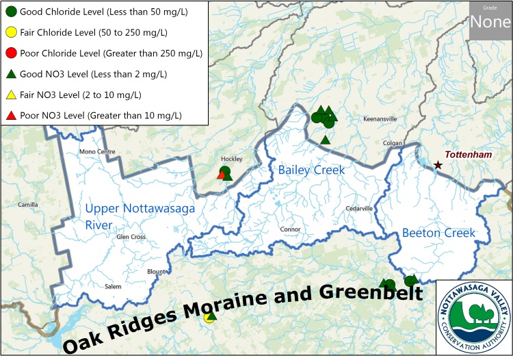 The map opposite shows only the chloride concentration measured in groundwater samples collected after January 1, 2000, and only for those wells that are considered to reflect the shallow groundwater (less than 21 m, close to the water table).
Shallow samples better reflect land use impacts on groundwater quality. In this part of Ontario, deeper samples, especially in the bedrock, are frequently influenced by natural brine waters as opposed to being influenced by land use or other human impacts at surface. Chloride was selected because of its conservative behaviour in the subsurface (that is, it tends to stay in aquifers) and its widespread use in winter to de-ice roadways and parking lots. | |||||
 Additional monitoring must be done within NVCA before any conclusions can be made about the health of groundwater in relation to nitrite and nitrate. The accompanying map shows that few groundwater quality analyses are available for characterizing the groundwater system. The Provincial Groundwater Monitoring Network (PGMN) has been established to monitor ambient conditions with annual sampling at some 450 wells across the province. Municipalities with groundwater-based supplies also regularly sample groundwater from wells that are part of their drinking water supply system. Outside of these programs there are few studies or even opportunities to collect groundwater samples, particularly on a repeatable basis, in Ontario. Additional monitoring, particular in urban areas as well as in areas that are slated for land use change, is recommended to track long-term trends on groundwater quality. | |||||
| Coldwater Fish and Stream Temperature |
 MORE INFO |
Trend: None MORE INFO |
|||
Coldwater Fish and Stream Temperature
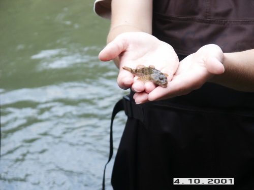
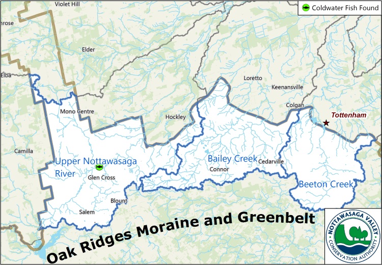
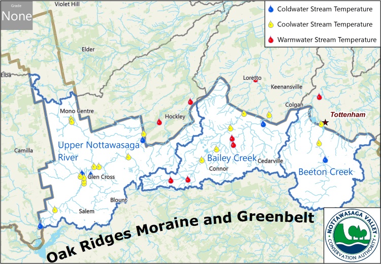
Brook trout and Sculpin were selected as coldwater indicators of ecosystem health. These native fish species are typical of the Oak Ridges Moraine (ORM) and Greenbelt study area, which is characterized by abundant groundwater discharge that supports their coldwater habitat. Changes in presence of these fish species may indicate degradation or improvement in various factors such as groundwater contributions, water quality (e.g., phosphorus, temperature, benthics and dissolved oxygen), riparian cover or physical stream condition. Coldwater fish communities are determined by stream temperature thresholds that relate to summer average and maximums. Where fish data is not available, stream temperature is a good surrogate for the presence of coldwater fish indicators or restoration potential. Fish Found / Not FoundThe Upper Nottawasaga River and its tributaries support healthy resident brook trout and brown trout populations as well as migratory rainbow trout and Chinook salmon. The headwaters of Bailey Creek and Beeton Creek provide habitat for resident brook trout. The broader Nottawasaga River watershed is one of the largest producers of rainbow trout and Chinook salmon in the Georgian Bay/Lake Huron basin. Only two fish collection records are available between 2008 and 2013 within the NVCA ORM and Greenbelt study area. Both sampling sites, located on the Upper Nottawasaga River, had sensitive coldwater species present. Historical and anecdotal evidence suggests that coldwater fish species are present in portions of all three subwatersheds; however additional data collection is required to confirm presence/absence as well as long-term trends. Stream Temperature To investigate the predominant thermal regime at sampling stations within the Oak Ridges Moraine (ORM) and Greenbelt study area, water temperature data was collected using HOBO Water Temp Pro temperature loggers. Data loggers were attached to weights and placed in the middle of the channel, ensuring that their placement was not in close proximity to groundwater upwellings, or in an area where warm water inputs would have an impact on the data collected. Water temperature data records between 2008 and 2013 were available for all three ORM /Greenbelt subwatershed areas. The Upper Nottawasaga River is dominated by cool and coldwater streams. Bailey Creek supports a mix of coolwater and warmwater habitats, while limited sampling in Beeton Creek indicates the presence of cool and coldwater conditions. |
|||||
| Back | Coldwater Fish and Stream Temperature | Fish Found | Stream Temperature | ||
|
Brook Trout Sculpin 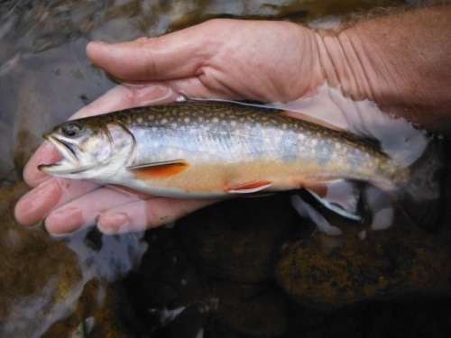
| |||||
As a new addition to the report card, this indicator is important because some conservation authorities have noted a decline in Brook Trout populations over time (e.g., Credit Valley Conservation has documented a statistically significant decline across 18 sites since 1999). Coldwater fish can be negatively impacted by climate change and other stressors associated with land use change. Land use mitigation and restoration efforts may offset such trends. | |||||
Managing for cooler water temperature regimes through riparian planting and dam decommissioning will improve water quality and fish habitat and will also benefit subwatershed forest cover. These forms of management are needed to buffer potential thermal impacts associated with climate change. NVCA staff continue to work closely with landowners to support these forms of stewardship. | |||||


| |||||